This article was published in partnership with Inside Climate News, a nonprofit, independent news outlet that covers climate, energy and the environment.
An unusually harsh downpour that was probably supercharged by climate change swelled the Sagavanirktok River in the Brooks Range of northern Alaska in the late summer of 2019.
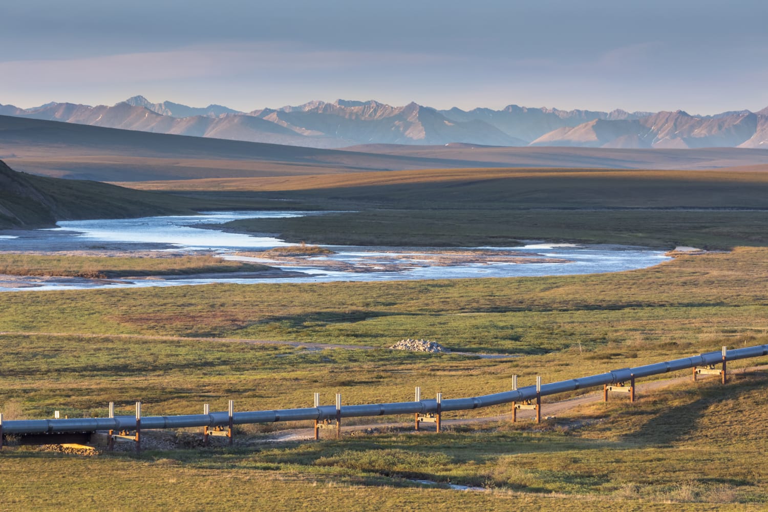
Chunks of earth crumpled into the churning water in August as the river chewed away 100 feet of the land on the west side of the Sag, as the river is commonly called, reaching within 30 feet of a buried segment of the Trans-Alaska Pipeline.
The 4-foot-diameter pipe carries an average of 20 million gallons of crude oil a day from the Prudhoe Bay oil fields, and if floodwaters reached a buried section of pipeline at full strength, the force would buffet the pipe like waves slapping a sailboat on stormy seas. Rushing water could scour away the ground supporting the buried pipeline, leaving it hanging unsupported and vulnerable to collapse, while above-ground sections of the pipe could be weakened if water washed away the earth anchoring its support structures.
“Unlike hazardous liquid releases on land where it can be easier to respond to and contain spills, swift-moving river currents will carry hazardous liquids further downstream, potentially impacting much larger geographical areas and more communities,” the Pipeline Hazardous Materials Safety Administration, the federal agency responsible for enforcing pipeline safety, told pipeline operators in a 2019 bulletin.
Two months after the flood, the close call prompted the Alyeska Pipeline Service Co., a syndicate of oil companies that owns and operates the Trans-Alaska Pipeline System, or TAPS, to seek authorization from the Alaska Department of Natural Resources to fortify the banks of the Sag to protect the pipeline from floodwaters.
But since then, the flood threat has grown, which spurred Alyeska to seek additional authorization last year to build three massive flood control walls along other sections of the river “to protect TAPS from current and future flood events.”
The increasing urgency to fortify sections of pipeline against thrashing floodwaters foreshadows what scientists, pipeline consultants and environmental advocates say is a future in which infrastructure like the Trans-Alaska Pipeline will face increasing assaults driven by the warming climate, including floods, wildfires, thawing permafrost and rising sea levels. Mitigation measures need to be charted into the future, they say, rather than applied like Band-Aids as the damage materializes.
Flooding along the 800 miles of the Trans-Alaska Pipeline has intensified as rising temperatures hasten snowmelt and amplify rainfall surges. Rivers paralleling the pipeline are reaching higher levels for longer periods, increasing their potential to wash out the pipeline and touching off frantic fights to prevent their churning waters from reaching it.
“What we are seeing now are changes in terms of higher river [flow] peaks, the duration of flooding and the seasonality,” said geomorphologist and river science consultant Karin Boyd, the owner of Applied Geomorphology Inc. of Montana. “This raises the question of ‘Do we need to look very carefully at whether the pipeline is more exposed now than it has been before?’”
When the floods came
The flooding in 2019 was just the beginning of a series of close calls.
The surging waters began in March, when Alyeska confronted flooding on the Lowe River near the pipeline’s terminus in Valdez. The river had steadily eroded 300 feet of bank in the direction of a section of the buried pipeline, generating a request by Alyeska to add a wall of riprap — a combination of rock and gravel — to “mitigate further erosion and exposure of the pipeline.”
Then, in May, Alyeska found itself in a pitched battle for five days to save the pipeline from the Dietrich River. As the heat accelerated snowmelt from the Brooks Range, the river overflowed and surged toward an elevated section of the pipeline 37 miles north of Coldfoot, a truck stop along the Dalton Highway.
Records filed with the state’s oil and gas division describe the tense fight early on to protect the pipeline against “aggressive bank erosion” that brought the heaving river to within 80 feet — less than the length of a basketball court — of supports holding up an above-ground section of the pipeline.
Temperatures jumped above average for 15 days from May 15 to June 1, some days soaring as high as 13 degrees above normal, according to data assembled by the Alaska Center for Climate Assessment and Policy.
Alyeska, an association of oil companies that includes a subsidiary of Hilcorp Energy Co., as well as ConocoPhillips and ExxonMobil, responded to the “aggressive nature of the bank erosion and continued high flows” by placing riprap between the river and the pipeline, eventually increasing the pile to 185 feet in length.
A few days later, about 600 more cubic yards of material — 200 feet long by 30 to 40 feet wide — were added to the existing barrier to stabilize about 400 feet of the water’s edge where the river was undercutting the bank.
The all-hands defense prevailed. But the fight wasn’t over.
A July 2019 heat wave of “astonishing intensity” unleashed record temperatures into the 80s and 90s across Alaska.
Then, in August, rain gauges registered 171 percent higher precipitation than the 30-year average when the downpours hit the headwaters of the Sagavanirktok. The usual rainfall total for the region is about 3 inches for the month; it more than doubled that fall in 2019.
The summer deluge fits the long-term pattern of increasing rain in the central and eastern regions of Alaska’s North Slope, which today get 15 percent to 35 percent more precipitation than they did in the early 1970s, according to records kept by the Alaska Center for Climate Assessment and Policy at the University of Alaska, Fairbanks.
Such downpours are increasingly being fueled by evaporative moisture from the warming of the Bering Sea, said Rick Thoman, an Alaska climate specialist with the climate assessment center. The added moisture in the atmosphere supercharges the traditional summer storms along the North Slope.
“It’s important not just to look at how high the river got but consider the significance of the causative effect,” he said. “This was the result of approximately a single rainstorm.”
In June 2020, Alyeska again found itself where it began in 2019: scrambling to protect a section of pipeline buried 10 feet deep when the Lowe River roared to life and flooded near Valdez, eroding a 100-foot buffer between the riverbank and the pipeline. The company brought in heavy machinery to place up to 2,000 cubic yards of riprap to fortify 300 feet of the eroded bank.
The fight prevented the Lowe River from washing out the pipeline, but it and other recent battles to hold back surging rivers reflect the increasing peril environmental activists say the pipeline is facing from floods.
Stockpiling emergency material
Alyeska spokeswoman Michelle Egan declined to answer specific questions about floods that have threatened the pipeline or the organization’s overall flood mitigation plan. She said in a statement that the pipeline was constructed and maintained in consideration of Alaska’s “unique” environment and that Alyeska has an integrity management program that includes a team of engineers who specialize in monitoring rivers and flood plains.
“The program monitors stream crossings and flood plains along the route of the pipeline,” Egan said. “Flow rates and water levels traditionally shift and vary. We collect, store and analyze data for trends to proactively protect the pipeline.”
Over the years, Alyeska has taken additional measures to protect the pipeline from flooding by constructing simple earthen dams nearby or surrounding the pipe with wire cages filled with heavy rocks.
But new climate threats are challenging the old design standards that have kept the pipeline safe for decades. Along with the certainty of more deluges, the floods in the last two years have led Alyeska to seek approval from the state to construct barriers to fortify vulnerable sections of the pipeline along its entire north-to-south route.
Alyeska sought permission in May 2020 from the state Department of Natural Resources to stockpile 200,000 cubic yards of gravel, sand and rocks to be used to construct emergency barriers along a 67-mile section of the river above the Arctic Circle should it surge toward the pipeline again.
Source: | This article originally belongs to Nbcnews.com