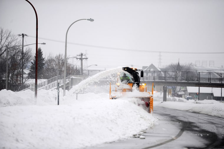
Warmer weather is expected to spread across much of the U.S. over the next three days following a deadly winter storm that killed more than 60 people and walloped New York’s Erie County, while five separate storm systems are expected to bring double-digit rainfall and three feet or more of snow to the West through early next week.
Highs of 5-20 degrees above average are expected through the holiday weekend in much of the country, which will help melt the snow in Erie County’s Buffalo area and lead to a mild New Year’s Eve and Day for most areas east of the Rockies.
Highs are expected to top 50 degrees Fahrenheit in Washington, D.C., Denver and Atlanta on Wednesday, while Dallas could see highs in the high-60s and low-70s Wednesday through New Year’s Day.
In Chicago, highs will be comparatively more moderate, in the low 40s on Wednesday, potentially reaching 55 degrees Thursday and stabilizing in the mid-40s Friday through New Year’s Day.
Buffalo sees relief
In Rochester and Buffalo, temperatures are expected to reach the mid-40s on Wednesday and continue climbing to the low 50s by Friday, according to the National Weather Service.
The region has already seen some relief from the winter storm that left thousands without power and digging out of several feet of snow: Tuesday night marked the first time in over a week that the Buffalo area had no winter weather warnings in effect, the National Weather Service Buffalo tweeted.
The Buffalo Airport, which has been closed since Dec. 23, was expected to reopen on Wednesday morning, according to a tweet.
A little more than 1,400 energy customers in New York state were without power Wednesday morning — amounting to only 0.02% of the state — according to PowerOutage.us.
In Erie County — where at least 32 people died from the storm, according to an NBC News tally — power was fast being restored, with about 800 of the county’s 350,700 energy customers remained without power Wednesday morning, compared to more than 2,000 who were without power Tuesday night.
Storms to batter the West Coast
Meanwhile, a total of five separate storm systems will impact the West through next Monday.
A storm system is expected to bring snow and wind gusts up to 70 mph to the Rockies and Four Corners regions on Wednesday.
On Thursday, the next storm system makes its way on to the West Coast, with a flood risk developing across portions of California. Friday, a storm system will continue to bring coastal rain and heavy mountain snow.
By the time the parade of storms moves through the West, double-digit rainfall totals and three feet of snow or more will have fallen.
Stormy weather has already impacted parts of the West.
In the Northwest, monster waves, high tides and strong winds battering western Oregon and Washington led to fatal crashes, power outages and flooded homes on Tuesday and early Wednesday.
Oregon State Police said multiple people died when their car hit a tree on U.S. 26 east of Cannon Beach, The Oregonian reported. Investigators are determining whether the tree fell on the roadway before the car hit it or if the tree crushed the vehicle when it fell, police said. The exact number of people killed wasn’t immediately known.
Another motorist was killed when a tree fell and struck their vehicle while driving farther east on U.S. 26, ABC affiliate KATU of Portland reported, citing Oregon State Police. More than 50 miles of the highway was shut down because of that crash, downed trees and high winds — from Rhododendron to Warm Springs, state transportation officials said.
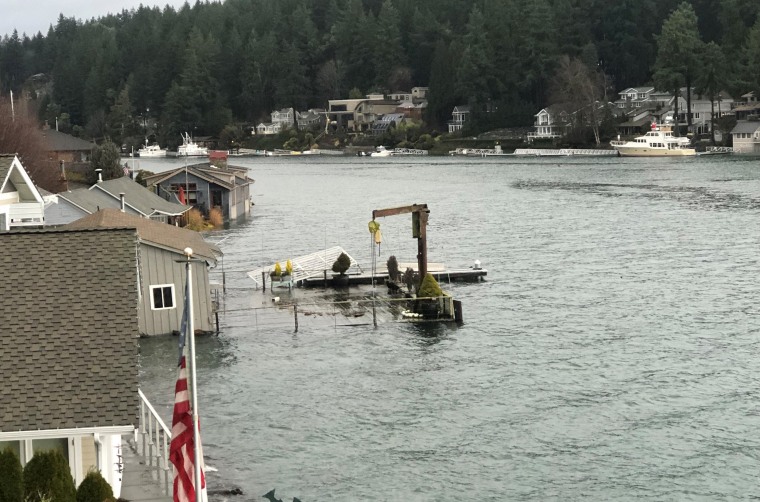
In Washington, high tides known as king tides and heavy rains caused water to spill into more than a dozen homes in Seattle’s South Park neighborhood, The Seattle Times reported.
As of Wednesday morning, Oregon led the country as the state with the highest number of reported power outages — with more than 66,000 customers affected — according to PowerOutage.us.
More than 14,600 people in Washington’s King County were also without power Wednesday morning, and thousands more in Kitsap and Thurston counties, in the western part of the state, were also without power, according to PowerOutage.us.
Along Oregon’s north coast, winds hit 80 mph Tuesday. In the Portland metro area, wind gusts of 60 mph downed powered lines and felled trees, including near the Portland Art Museum downtown.
Coastal flooding and high wind advisories were also in effect for much of western Washington state.
A record high tide of 18.4 feet submerged parts of the state capital of Olympia, sweeping marine life into the city’s streets, officials said.
“Jellyfish washed over the shoreline and into our streets,” said Olympia Water Resources Director Eric Christensen. “There was a woman who was kind enough to rescue them and put them back into Budd Inlet.”
Other areas around Puget Sound also saw flooding, which trapped cars and impacted buildings
The weather conditions also forced the full or partial closure of several Oregon state parks at a time when whale watchers and holiday tourists typically flock to the coast.
Oregon State Parks announced emergency closures for Ecola and Cape Meares because of high winds and the potential for falling trees. The day-use area at Sunset Bay State Park near Coos Bay was closed because of extreme high tides and flooding.
Cape Meares is one of 17 sites hosting Oregon’s Whale Watch Week, which is returning in-person this year for the first time since the pandemic. During the event, which starts Wednesday and lasts through Sunday, volunteers help visitors spot gray whales during their annual migration south.
The park anticipates reopening on Wednesday, but people are advised to visit later in the week if possible, said Oregon State Parks spokesperson Stefanie Knowlton.
In California, the first in a week of storms brought powerful winds, rain and snow to the state on Tuesday, substantially lowering temperatures that topped 80 degrees in some areas over Christmas.
There were numerous reports of roadway flooding and downed trees and branches as the storm blew into the northern half of the state and spread south, the National Weather Service said.
More than 9,600 California energy customers were without power Wednesday morning, with Humboldt county reporting the most outages, at more than 2,500. Colusa and Mendocino counties had 650 and just over 700 power outages as of Wednesday morning, respectively, according to PowerOutage.us.
Winter storm warnings were issued for the Sierra Nevada, where motorists were advised that travel could be hazardous. Chains or snow tires were required on some highways.
Gusts up to 120 mph were recorded on some Sierra ridgetops, the Reno, Nevada, weather office said. Backcountry avalanche warnings were issued for parts of the mountain range.
Source: | This article originally belongs to Nbcnews.com