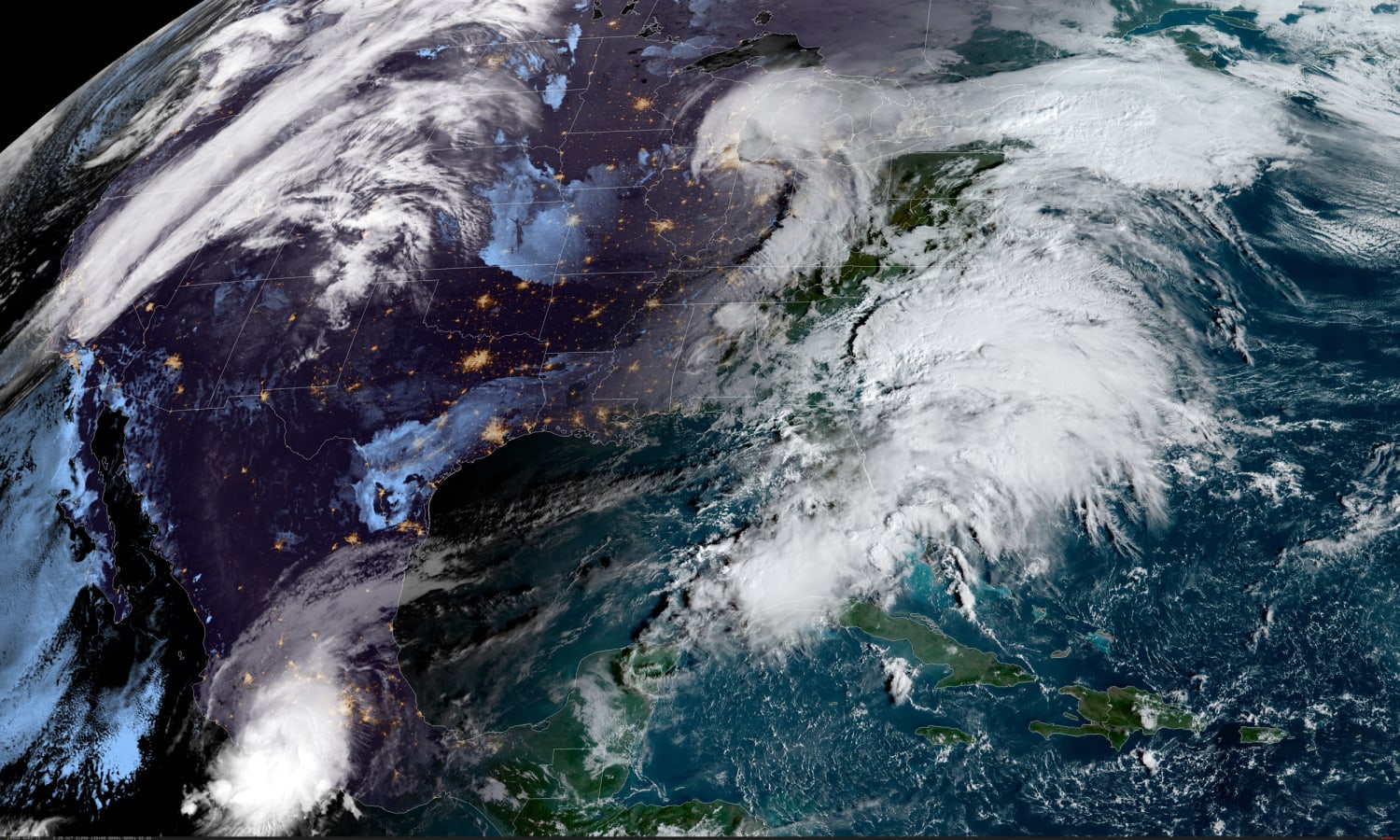

Over the weekend the strongest storm to ever hit the West Coast slammed onshore, packing strong winds, record rainfall and heavy Sierra snow. On the East Coast, tens of millions braced Monday for the season’s first nor’easter.
The first days of the week is poised to bring extreme rain to much of the country. In total, more than 90 million people will experience dangerous weather in the form of high winds, flooding rainfall or severe thunderstorms through Wednesday.
Over the weekend in California, a storm system dropped to a barometric pressure of 945.2 mb, making it the strongest storm to affect the Pacific Northwest on record. For perspective, this is equivalent to the central pressure you would see with a strong hurricane.
In fact, Mammoth Mountain, California, clocked a 111-mph wind gust.
As the storm system roared into the region, it dropped 4.02 inches of rain in downtown San Francisco, making it the wettest October day on record. With nearly 7 inches of rain for the month, San Francisco is now having its second wettest October on record.
For Sacramento, the stats are even more startling. Sacramento picked up 5.44 inches of rain Sunday, making it their wettest day in history (or any calendar month). Making this even more remarkable is that this came on the heels of a record dry streak of 212 days in a row with no measurable rain. That just ended on Oct. 18.
This example of drought to deluge, also known as precipitation volatility, is exactly what’s expected to occur more frequently in California with climate change, where a moisture-loaded Pacific storm system brings a brief period of record rainfall in the middle of an extreme drought exacerbated by record high temperatures.
On Monday morning, 7 million people remained under flood alerts and 18 million people under wind alerts. Heavy rain was expected to continue across much of California, where rainfall rates of 1 inch per hour at times will keep the risk for flash flooding, landslides and mudslides high through Monday night. The winds will also stay strong, with wind gusts up to 70 mph especially at the highest elevations.
Additional rainfall totals will be 3 to 4 inches, and by the time the storm moves out of the region on Tuesday 2 to 3 feet of fresh snow will blanket the Sierra.
If there was any good news that came out of the powerful western storm, it’s that the Dixie Fire is 100 percent contained and Lake Oroville rose nearly 10 feet due to the beneficial rainfall. This summer, the Dixie Fire became the second-largest wildfire in California, eclipsed only by the August Complex Fire of 2020. At the same time, Lake Oroville reached an all-time low, shutting the power plant down for the first time in history.
Meanwhile, on the other side of the country, the Mid-Atlantic was bracing for severe thunderstorms on Monday, while the Northeast and New England braced for the first formidable nor’easter of the season.
Sunday night into Monday morning, the storm heading toward the Mid-Atlantic spawned several likely tornadoes across parts of Missouri and Illinois. The National Weather Service will send out survey teams on Monday, but radar imagery and damage reports indicate the tornado that struck Madison County, Missouri, may have been a strong tornado (EF3+).
On Monday, 31 million people were under flood alerts across the Northeast and New England, including New York City and Boston. Six million people were under wind alerts across eastern Long Island and southern New England, including Boston and Providence, Rhode Island.
On Monday, the storm system was expected to move east out of the Ohio Valley and into the Mid-Atlantic bringing the risk for severe storms to 16 million people across parts of Virginia, West Virginia and North Carolina. Cities in the risk zone included Charlotte and Richmond with Washington on the fringe of the severe weather threat. Wind will be the greatest risk followed by isolated tornadoes.
On Tuesday, the storm system will transfer its energy to a developing coastal storm off the Atlantic coast and affect the Northeast and New England. The main risks will be rainfall rates of 1-2 inches per hour and strong winds.
The heaviest rain was expected to begin Monday night for New York City and early Tuesday for Boston.
And it’s not just the bookends of the country expected to experience extreme weather over the next few days, but also the middle of the country.
Eight million people are at the risk for severe storms Tuesday across the central and Southern Plains. Hail as big as softballs will be the main risk, followed by damaging winds in excess of 70 mph and isolated tornadoes.
On Wednesday, this storm system will shift east bringing the risk for severe storms to portions of the Gulf Coast. This risk will include 12 million people in the metro areas of Houston, New Orleans, Baton Rouge, Louisiana, and Mobile, Alabama.
Source: | This article originally belongs to Nbcnews.com