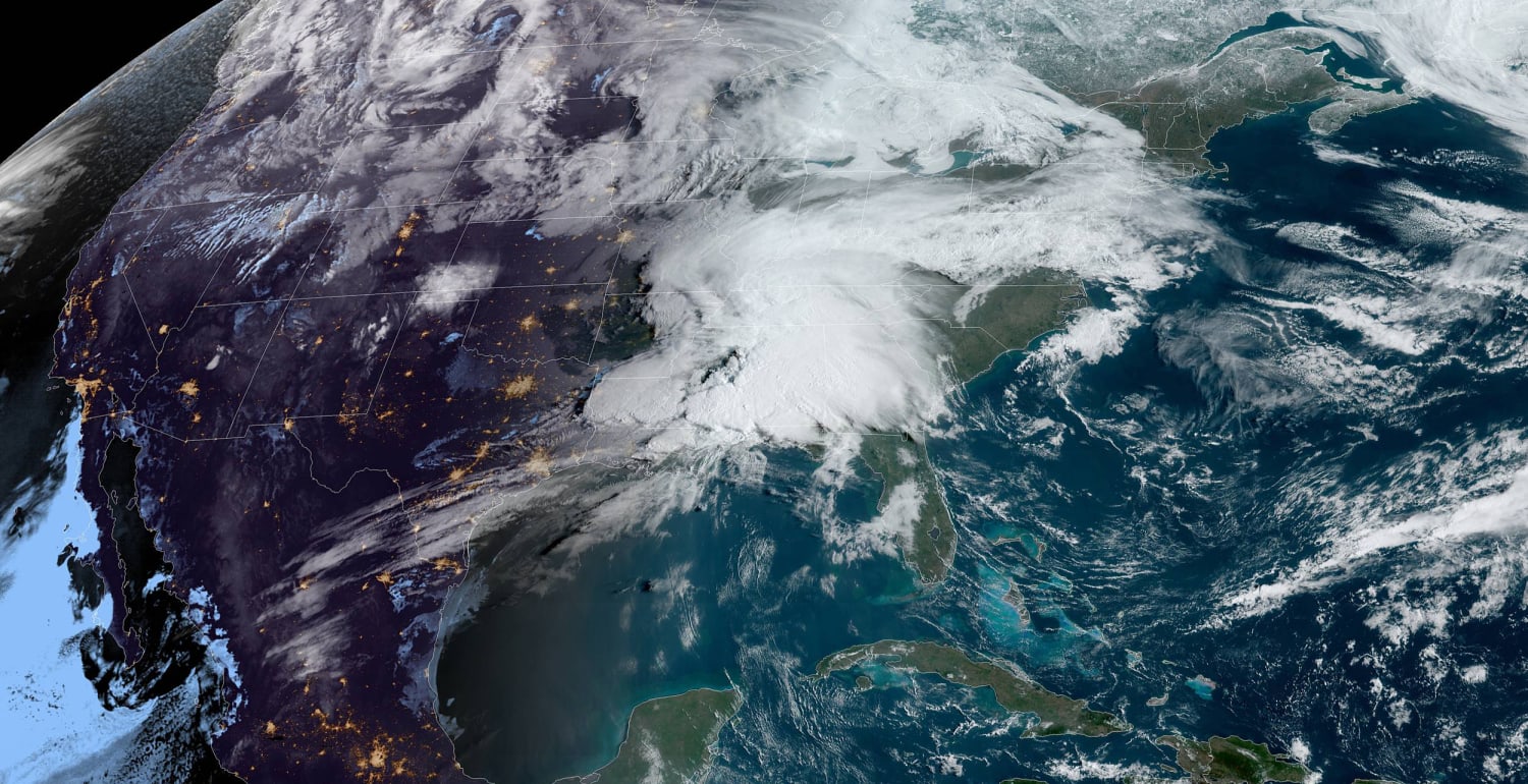
Two separate storm systems will bring the risk of severe thunderstorms Tuesday through Thursday. Tornadoes, large hail, damaging winds up to 75 mph and flash flooding will all be possible for the millions who will be in the path of the storms.
On Tuesday morning, a powerful line of severe thunderstorms was already charging across parts of the Gulf Coast states and Southeast prompting multiple tornado watches for the metro areas of New Orleans; Jackson, Mississippi; Montgomery, Alabama; and Pensacola, Florida.
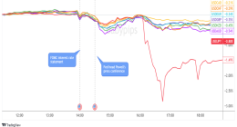
These tornado watches, one of which was in effect until 2 p.m. CT, were a sign of a dangerous day ahead. About 22 million people are under risk for severe storms on Tuesday, stretching from southeastern Louisiana to the South Carolina coast.
The greatest risk was forecast to be wind gusts in excess of 75 mph, but a few strong tornadoes were also possible.
Additional cities like Birmingham, Alabama; Atlanta; Tallahassee, Florida; Savannah, Georgia; and Charleston, South Carolina, were also put on alert for dangerous storms headed their way.
As this first storm system exits later on Tuesday, it will bring some heavy rain to portions of the mid-Atlantic and Northeast, from Washington to New York beginning late Tuesday morning and lasting through Wednesday morning’s rush hour.
As the first storm system exits, the second storm system will enter.
Forecast to dive out of the Plains and Midwest on Wednesday, the northern side of the storm system will feature snow and wind across the Upper Midwest and northern Great Lakes, while the southern side is expected to bring more severe storms for 30 million people across the Southeast.
The severe storm threat on Wednesday will affect many of the same areas hit Tuesday, including the metro areas of Atlanta; Birmingham; Mobile, Alabama; Charleston; Tallahassee and Jacksonville.
By Thursday, severe storms will be confined to eastern North Carolina and small portions of coastal South Carolina and Virginia, from Myrtle Beach to Virginia Beach.
In addition to the severe storms, flooding will also be a concern. A Flood Watch was in effect on Tuesday for portions of southern Mississippi, southern Georgia and northern Florida. Rainfall totals of 2 to 4 inches, locally up to 5 inches, could fall through Thursday. Rainfall rates could be 2 inches per hour at times.
After Thursday, there will be a lull in widespread severe weather over the weekend, but it won’t last long.
Next Monday through Wednesday will likely feature yet another multiday round of severe storms across the central and southern Plains and parts of the Southeast. All hazards will be possible.
This would make the fourth week in a row with severe storms across in what has been a relentless streak of severe weather across the southern tier of the United States.

Source: | This article originally belongs to Nbcnews.com